


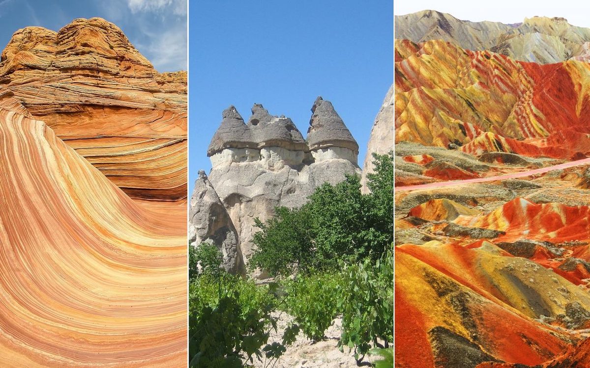
Water, wind and time have spent millions of years shaping these landscapes. Their shapes are not accidental. They are a direct result of the rock material, plate tectonics and the specific climatic conditions to which they were exposed.
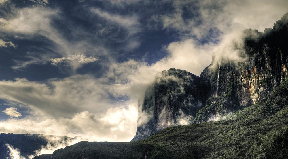
Mont Roraima: A geological relic
One of the most striking examples can be found in Venezuela, near the borders of Brazil and Guyana. This is Mont Roraima. It’s a table mountain. It is about 10 kilometers long. It rises 1000 meters above the surrounding tropical forest and savannah.
The stone mass is one of the oldest on Earth. It is made of sandstone, silica and quartz. Erosion created natural ponds and caves on its surface. The formation looks like a deserted island floating in a green sea.
Did this strange place inspire fiction? Yes. Sir Arthur Conan Doyle used it as inspiration for his novel The Lost World. The Pixar film “Up” also drew from its unique shape.
“This strange geological formation resembling a desert ‘island’ has influenced major works of fiction.”
Why is it important? It offers a glimpse into deep time. The rocks have survived continental drift and climate change. Today they are a monument of geological endurance.

How Chocolate Hills got its name and shape
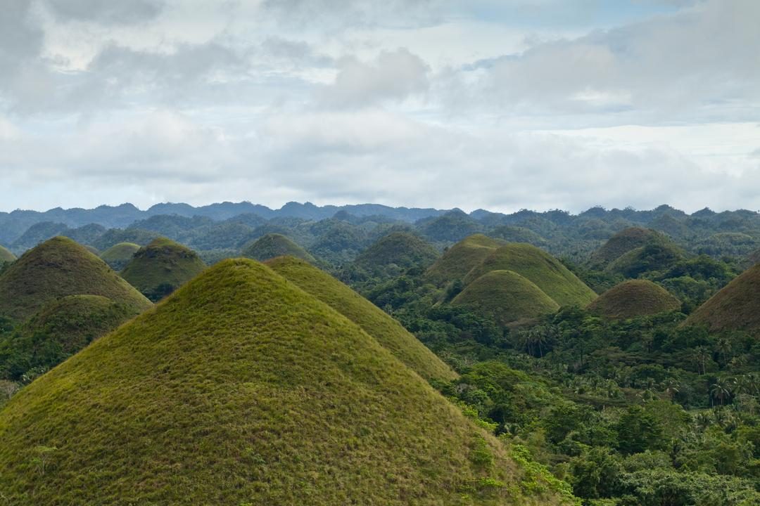
The Chocolate Hills aren’t chocolate. They are made of limestone and sand. But when the dry season comes, they turn a distinct, rusty brown. The name comes from this color change.
These geological oddities are anything but ordinary and are located on the island of Bohol in the Philippines. There are about 1,776 of them. They cover 50 square kilometers of land. Each hill is 30-50 meters high.
From a geological point of view, their origin is surprisingly recent. The process started about two million years ago. Sedimentation did the heavy lifting. Sand mixed with calcium carbonate. The carbonate came from corals and shells. Over time, layers formed.
Then the rain took over.
Erosion created hills out of soft rock. Rainwater dissolved the material. These iconic, cone-shaped structures were born. Grass covers the tops. They are green in the rainy season. They turn brown in the dry season. They look like giant molehills.
Why are they important? They are a rare example of limestone formation on land. Most similar structures are located underwater or in caves. The Chocolate Hills show how water and time can transform a landscape into something that seems to belong on another planet.
Visitors often ask if they can climb them. Some hills have hiking trails. Others are protected. The terrain is fragile. The erosion that created them can also undo them.
The hills don’t just lie there. They change. Season after season. Year by year. Color returns. Then it fades again. It is a cycle written in rock and rain.
What happens the next time it stops raining? The brown comes back. It always does.

Stone forest of Tsingy de Bemaraha
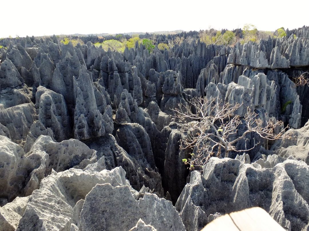
Imagine a cathedral made of rock but with pikes for pillars. This is Tsingy de Bemaraha in Madagascar. The name “Tsingy” actually comes from the local Malagasy language and literally means “where you can’t walk barefoot”.
It looks like a forest of sharp limestone needles. These rugged sides have been shaped by erosion over centuries. The story starts way back in the Jurassic period. At that time, the western part of the island was below sea level. The shells settled there layer by layer and formed fossil layers.
Then came the uplift.
A massive landslide shoved this giant plate up from the sea. Rainwater did the rest. It dissolved the limestone, eating away the soft stuff, and leave behind this fractured, dizzying landscape.
Why is this place important beyond just its danger? It is a unique geological record. The history of the earth’s crust can be seen from these sharp edges. It’s not just a pretty sight. It’s a reminder of how powerful water and time can be.

The striped hills of Gansu
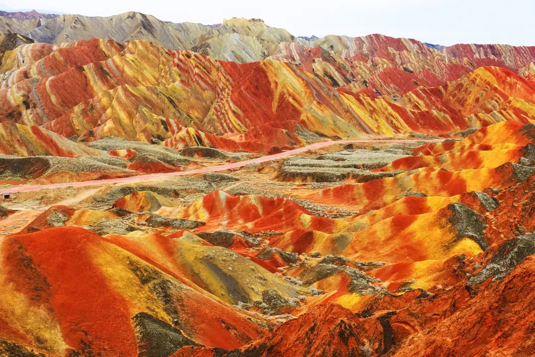
The landform of Zhangye Danxia in Gansu Province is not only a beautiful sight. It’s a geological timeline condensed into vibrant colors. These mountains located in northwest China look as if they were painted by someone with a reckless brush. The reality is slower. Much slower.
The formation of these sedimentary layers took 24 million years. Each layer tells a different chemical story. The colors you see are not surface colors. They are the rock itself.
Why are there stripes?
Depends on the minerals. The striking red bands are from hematite. This is iron oxide. The color of green areas is due to chlorite. Yellow tones? They come from sulfur trapped in iron deposits.
This particular mix creates what scientists call a multicolored landform. It is unique in its intensity. Erosion has removed topsoil and exposed the geological history.
“Each color depends on the composition of the stone.”
You might wonder how such different layers survived. They didn’t always do that. Tectonic forces lifted the sediment. Then the wind and water began to carve. Softer layers wore away faster. The harder bands stayed. This erosion created the ridges and valleys we see today.
For tourists, it is a surreal landscape. For geologists, it is a clear record of ancient environments. Iron-rich layers show periods of oxidation. Chlorite shows different chemical conditions at that time.
The result is a natural color gradient. No two spots look exactly the same. Light also changes everything. The morning sun makes the reds burn. The evening shadows deepen the green.
It reminds us that time leaves its mark. Just not the ones we normally expect.

Myth vs. Geology
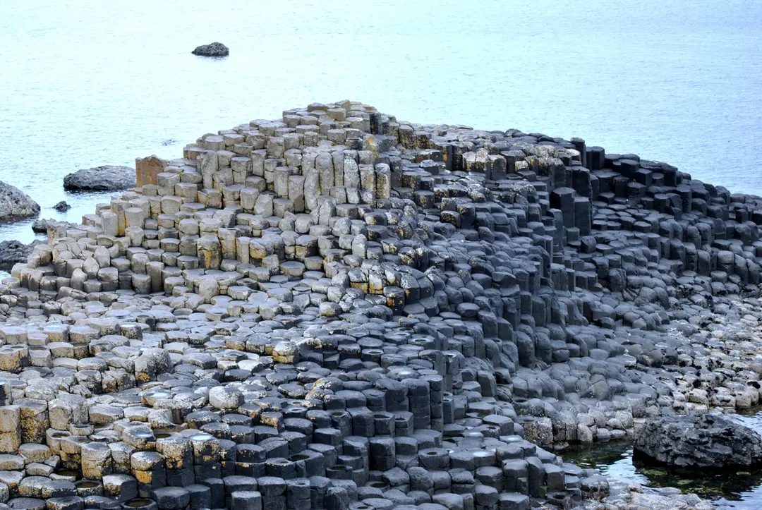
Step onto the northern coast of Northern Ireland and you’ll see what looks like a staircase carved especially for giants. It is an optical illusion created from basalt, not imagination. Legend has it that Finn McCool built this path to get to Scotland. According to geology, something much more mechanical happened 60 million years ago.
A huge lava flow erupted. It was hot. It was liquid. Then it cooled down. Quickly.
Why shape?
As the lava cools, it shrinks. This contraction is key. As the basalt solidified, the tension increased until the rock broke. It didn’t break by accident. It fractured into geometric columns.
Most of these columns are hexagonal. Six sides. Why? Because the hexagon is the most efficient shape to fill space while minimizing surface area for cooling. It is a natural result of physics, not design.
But take a closer look. You see pentagons. squares. Heptagons. Four, five or seven sides. The variation is what makes the formation so striking. The irregularity indicates that the cooling process was chaotic and uneven.
Scale
About 40,000 of these columns are packed together. They interlock. Some rise from the sea. Others climb the cliff face. The sheer volume creates a landscape that looks artificial but is nevertheless completely natural.
The contraction of the cooling lava created irregular fractures that eventually formed into geometric shapes.
Why it matters
This isn’t just a pretty sight. It is a textbook example of columnar jointing. Geologists study such places to understand how magma chambers cool and how continental crust forms. The Giant’s Causeway provides a clear and accessible look at the process that shaped much of Earth’s early volcanic activity.
It is important because it connects the myth of giants with the reality of plate tectonics. The giants didn’t walk here. The earth moved, the lava flowed out and the rocks cooled. But the result is still breathtaking.
Today you can walk between the columns. The path is steep in places. The wind is cold. But the geometry remains. Six sides. Or five. Or four. It depends on how the lava chose to shrink that day.

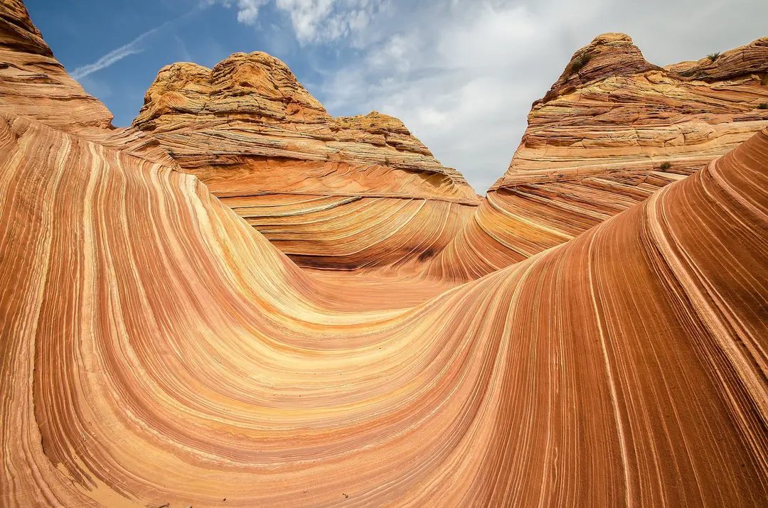
The red and ocher waves of The Wave in Arizona look like they were painted with a fine brush. They are not. The wind carved them.
Located on the Arizona-Utah border in the Vermilion Cliffs National Monument, the site is a geological curiosity. It’s not a painting. It is sandstone.
The layers you see are fossilized dunes. They appeared 190 million years ago. Wind and water compacted the sand and clay. Over time, the softer stone wore away. What remained were these smooth, flowing curves.
The stone is fragile. For this reason, access is strictly controlled. Only 20 people come every day.
You can’t just show up. There’s a lottery.
This system is used to protect the site. Too many footsteps would destroy the delicate surface. The approval process is competitive. Most of the applicants are rejected. Those who win will get a rare opportunity to walk on a landscape that looks alien.
The path is steep. The hike is long. But seeing the actual formation changes the way you see the rock. It’s not just a stone. It’s time, frozen in a ripple.
Access is limited to 20 people per day through a lottery system to protect the fragile sandstone.
Why is this important? Because places like The Wave remind us that nature works on a different time scale. We are walking in history. The wind is still working. The colors change with the light.
It’s not just photography. It’s a lesson in patience and erosion.
Lock-in dates are published monthly. They sell out in seconds. If you miss them, wait. Or you can look at other, less restricted formations nearby.
But the draw pulls people in. Not just because of the colors. For the chance of standing inside a sculpture made of air and time.

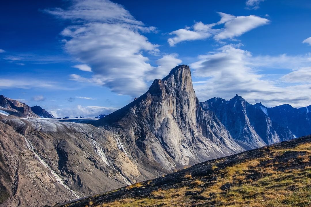
The granite tower of Mount Thor doesn’t just rise from the landscape. It juts out of it, defying gravity in a way that makes other peaks look like rolling hills. Located on Baffin Island in the Canadian territory of Nunavut, this geological outlier has a title that climbers and geologists alike respect with a mixture of awe and terror.
It has the world’s highest, almost perfectly vertical rock face.
Numbers are hard to digest. The steep wall drops to a depth of 1250 meters. That’s over 4,000 feet of empty space. But the angle makes it really weird. The average slope is 105 degrees. Yes, overhanging. Most vertical cliffs have an angle of about 90 degrees. It leans back. It is a massive overhang that seems to pull climbers into the sky rather than restraining them in the rock.
This creation did not happen overnight. It is the result of slow, brutal violence over millennia. Glaciers have dug into the granite, removing the softer material and leaving behind these jagged, impossible profiles. The peak itself is at 1,675 meters, but it’s the verticality that defines it.
When you stand next to it, you understand why it feels foreign.
Nearby Mount Asgard looks on from afar. At 2,015 meters, it is higher, but its character is different. Asgard is characterized by its twin peaks. They are flattened, almost like a table or a fortress wall with two towers. The contrast is sharp. Thor is the needle of vertical death. Asgard is a wide, impressive plain.
Why is this important beyond climbing stats? It challenges our understanding of structural stability. How does rock hold together under such extreme tension? The 105-degree angle suggests a geologic history of collapse and strengthening that scientists are still piecing together. It is a natural laboratory for understanding how mountains break and survive.
The isolation adds another layer. Baffin Island is remote. The weather changes quickly. Silence is heavy. Climbing Thor isn’t all about strength. It’s about navigating a landscape that seems actively hostile.
An angle of 105 degrees is not only steep. It’s a overhang that defies the usual rock climbing rules.
To those who study these formations, Thor is a mystery. It is a test for those who climb it. The granite is solid. The air is thin. The drop is real.
And Asgard? It waits.

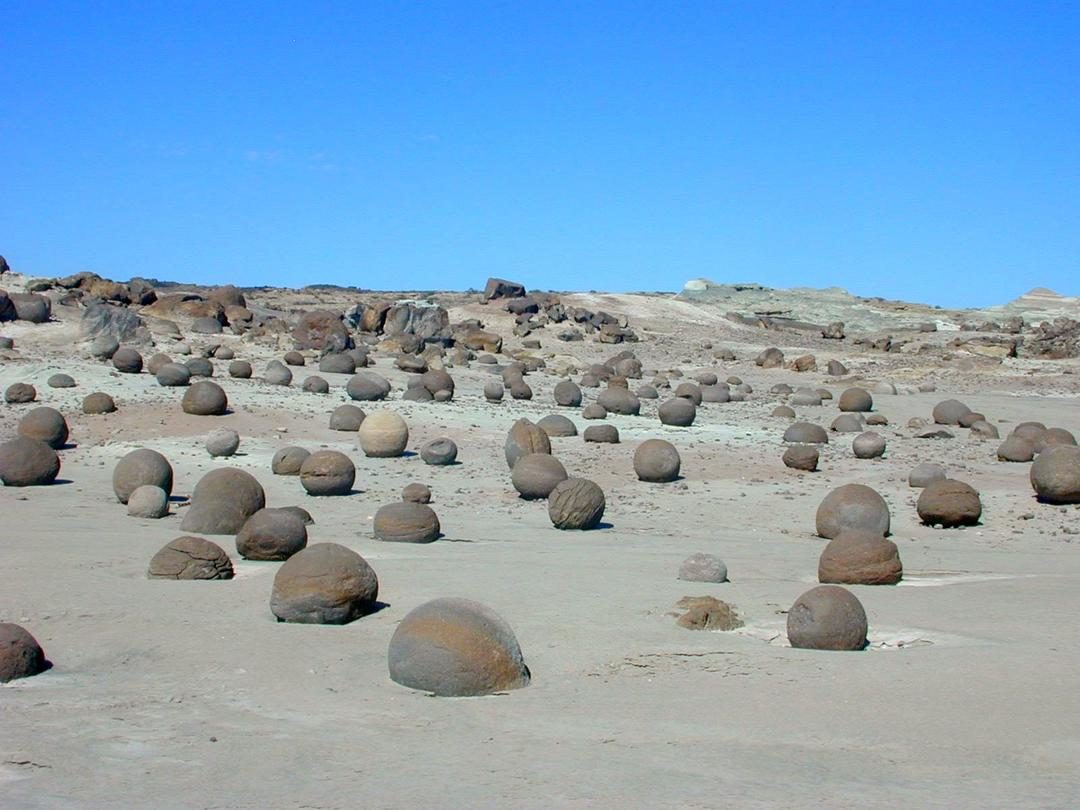
Why Argentina’s Ischigualasto is the ultimate prehistoric time capsule
If you’re in the northwest of Argentina, you’re not looking for beaches. Find Ischigualasto Provincial Park, a wild and unknown place locals call the “Valley of the Moon”. This is not an official nickname. This is a literal explanation. The landscape is dry, rocky, completely barren and jagged land that feels more like Mars than South America.
The park covers 63,000 hectares of this virgin land, but the real story isn’t the geography. This is what is buried beneath. These rocks were formed between 180 and 230 million years ago. At that time, the Earth’s climate was very different, and the Continents had not yet found their place. The result is a geological museum carved by wind and time, with geological formations whose names sound like something out of science fiction.
El Gusano (the worm), La Esfinge (the sphinx), El Submarino (the submarine) and La Cancha de Bochas (the bowling alley). Each name refers to a specific rock formation, but together they paint a picture of a landscape carved into strange shapes over time. Walking here feels less like a hike and more like walking through a dream where the land itself is steeped in history.
But the stone was just hidden. The real treasure is there. Ischigualasto is one of the most important fossil sites in the world. More than 25 fossils have been found, including the oldest known dinosaur. This is more than just a collection of bones. This is a glimpse into the moment when dinosaurs began to rule the Earth, driving out other reptiles and laying the foundation for their rule for the next 160 million years.
A Prehistoric Blueprint
伊斯奇瓜拉斯托的意义不仅仅在于其怪异的美丽。 它提供了对三叠纪时期的罕见一瞥,当时超大陆盘古大陆正在慢慢分裂。 这里发现的化石帮助科学家了解早期恐龙是如何进化、适应并最终占据主导地位的。 该地点不仅仅是一个墓地。 这是一个实验室。
研究人员研究这些化石是为了回答有关恐龙进化、气候变化以及塑造地球生命的灭绝事件等问题。 该遗址保存完好的化石清楚地记录了这一关键时期发生的转变。 如果没有伊斯奇瓜拉斯托,我们对史前生活的理解将会更加支离破碎。
公园的孤立性增加了它的吸引力。 远离阿根廷繁华的城市,这是一个可以感受到深沉时光的厚重的地方。 沉默是深刻的。 空气稀薄。 经过千年风化的岩石,静静地见证着一个早已逝去的世界。
“这就像行走在另一个星球的表面。”
这种比较并不夸张。 荒凉的地貌和年代久远的化石给人一种迷失方向的感觉。 你所站在的土地上见证了帝国的兴衰、大陆的更替以及生命从简单有机体到复杂野兽的进化。 这是一次令人谦卑的经历。
为什么今天很重要
了解过去有助于我们驾驭未来
The Striped Domes of Bungle Bungles
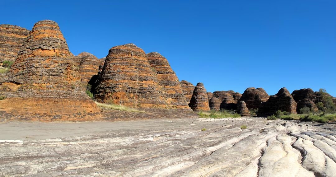
You’ve probably seen the pictures. These orange-gray domes rise from the Australian outback like they are from another planet. These are the Bungle Bungles in Purnululu National Park in Western Australia.
The geology here is old. Really old. The stone consists of sandstone, which was formed about 350 million years ago.
But the appearance of the place is a trick. A visual illusion created by moisture and biology. The stripes are not stacked layers of different types of stone. Everything is the same stone. The difference is on the surface.
Dark streaks? Their tone is richer. Clay holds water. When it rains, the moisture stays. A humid microclimate is created, which is ideal for cyanobacteria. These tiny organisms grow on the surface of rocks. They form a protective layer.
This coating does one thing: it prevents the stone from oxidizing.
Oxidation causes iron-rich rocks to turn rust orange. It’s the same process that causes a car door to rust. The cyanobacteria block the oxygen. They ensure that the underlying stone looks dark gray or anthracite.
The light stripes are different. They have less clay. Less clay means less water holding capacity. These layers stay drier. More porous. Without bacterial protection, oxygen can enter. Iron oxidizes. The stone changes the familiar bright orange you see in travel brochures.
The tiger stripe pattern is a surface phenomenon caused by moisture retention and microbial life, not geological layers.
It’s a delicate balance. Change the amount of rain and you change the colors. The clay layers dry out and the cyanobacteria die. The protective film disappears. Dark stripes turn orange. The contrast fades.
Bungle Bungles aren’t just rock formations. They are a biological clock. A living record of wet and dry seasons. A reminder that even the hardest stone can be softened by a thin film of life.

Fairy chimneys of Cappadocia: Why do they look like this?
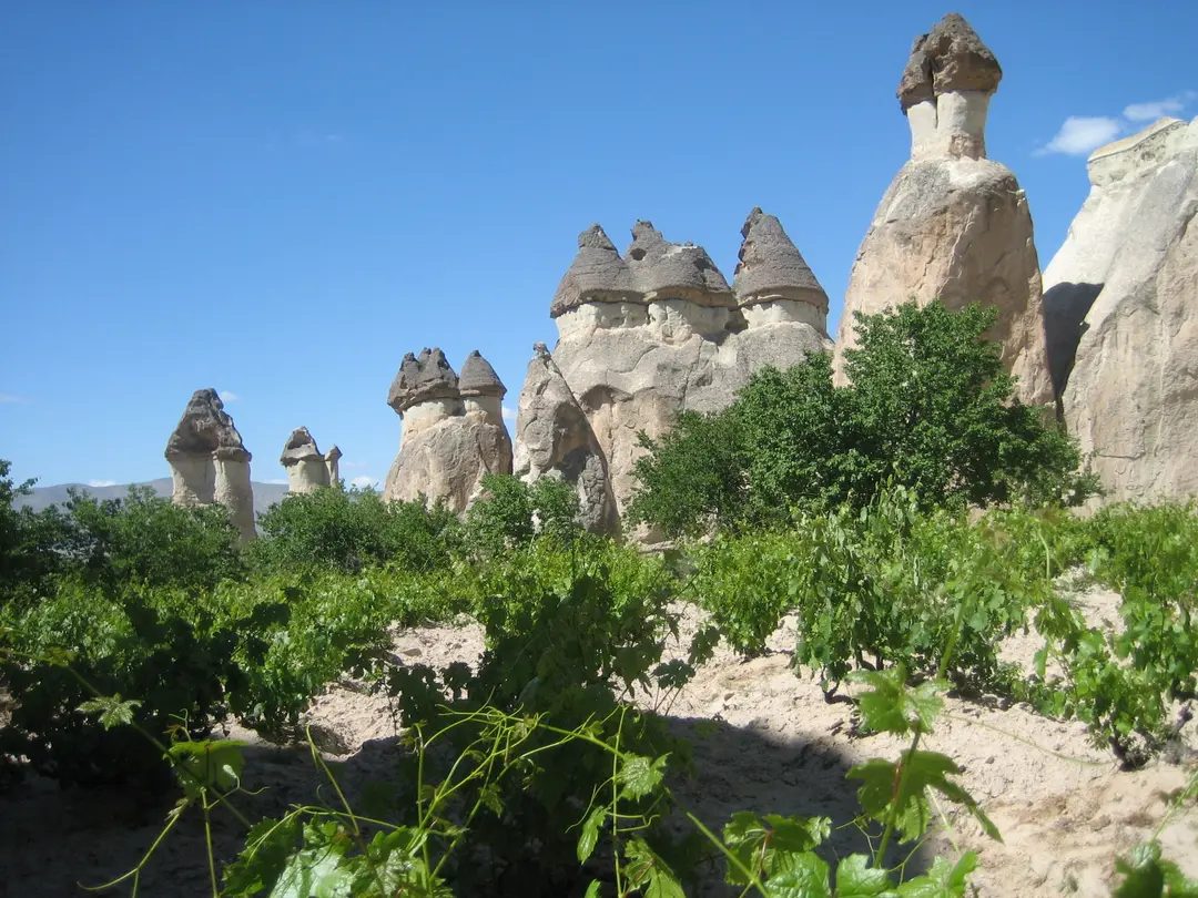
You’ve seen it too. Strange mushroom-shaped columns mark the landscape of central Turkey. They have two main names. Fairy Chimneys or demoiselles coiffées (translated as “arrogant women”). The visual impact is obvious. A hard cap-shaped rock rests on a soft tapering pillar. But how did they end up here? This is not magic. This is a long game of geology.
These structures have their roots in volcanic activity. Millions of years ago, the situation in this area was quite different. Volcanoes such as Mount Erciyes and Hasan Dağ spew ash and lava onto the ground. As the lava cools, it forms different layers of varying hardness. That layering is everything.
This structure is based on three special layers. The bottom has soft tuff (hardened volcanic ash). Then a layer of harder rock appears. Finally, there is the “hat”, a durable basalt hat. This basalt cap is the key to the chimney’s survival. It acts like an umbrella to protect the soft rocks below from the elements.
Without this cap, the column would quickly collapse. That’s why the pillars exist.
Natural means of erosion, such as wind, rain and freeze-thaw cycles, work relentlessly on exposed tuff. Soft stones wear away. The harder layers resist. result? Narrow at the waist and wide at the top. When the surrounding materials were stripped away, these structures have grown tall as high as 40 meters.
Basalt hats act as umbrellas and protect the soft rock below from the elements.
Why is this more important than beauty? These chimneys are more than just beautiful stones. The inhabitants of Cappadocia found themselves hollow for centuries. They carved houses, churches and entire underground cities directly into these soft volcanic tuffs. The hard caps protected these homes from heat and intruders.
So when you look at a fairy chimney, you’re looking at a layered history of volcanic fury followed by gentle, steady erosion. Basalt remains. Tuff retreats. In the middle stands a column, a geological monument to the selective collapse.
It’s a landscape that changes little by little every year. The cap may crack. The pillar may fall. This process is slow but continuous.
I can’t see the source article in the command prompt. If you want to rephrase it but keep all the facts and meaning, please provide the text you want me to work with.


