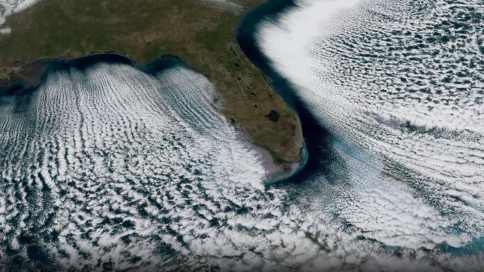
An extraordinary orbital view captured by the National Oceanic and Atmospheric Administration (NOAA) shows striking “cloud streets” extending from Florida’s coastline on February 1, 2026. The phenomenon occurred as unusually cold air pushed southward over the warmer waters of the Gulf of Mexico and the Atlantic Ocean, creating a spectacular atmospheric display.
What Causes Cloud Streets?
These parallel lines of low-level clouds form when frigid air flows over warmer water. The cold air absorbs moisture from the ocean surface, condensing into distinct, aligned belts. This effect is driven by prevailing winds, which dictate the clouds’ orientation. The image resembles the wake of a fast-moving boat, with clear stretches of dry air visible along the coast where evaporation has not yet occurred.
Record Cold in Florida
The cloud streets appeared during a period of unusually cold weather for Florida, with Tampa reporting temperatures as low as 30°F (-1°C). This extreme cold surge contributed to ideal conditions for cloud street formation. The event highlights how temperature contrasts between air and water can produce dramatic weather patterns.
How the Image Was Captured
The striking imagery was taken by the Advanced Baseline Imager on NOAA’s GOES-19 weather satellite. Positioned in geostationary orbit approximately 22,236 miles (35,785 kilometers) above Earth, GOES-19 remains fixed over the Americas, providing continuous monitoring of weather and environmental hazards.
GOES-19: A Powerful Earth-Observing Satellite
Launched in June 2024 aboard a SpaceX Falcon Heavy rocket, GOES-19 is equipped to track terrestrial weather, including hurricanes, as well as monitor space weather and its impact on Earth and orbiting spacecraft. Its geostationary orbit ensures constant observation of the Americas and surrounding regions.
The formation of cloud streets demonstrates the complex interplay between atmospheric conditions and oceanic temperatures, showcasing the power of satellite technology to capture these dynamic processes in real-time.
This observation is more than just a beautiful image: it illustrates the interconnectedness of Earth’s systems and the importance of ongoing weather monitoring for both terrestrial and space-based applications.
